
Dispatch from the Carbon Mapper Satellite Launch
An Unstoppable Coalition Tackles Methane Super-Emitters
The best things in life are worth waiting for. And after five years in the making, we have one more thing to add to this list: the launch of Carbon Mapper Coalition’s first (hopefully, of many) methane- and CO2-sensing satellite. The satellite, Tanager-1, built by Planet Labs with state-of-the-art technology from NASA JPL, was made possible by a first-of-its-kind philanthropically funded public-private partnership that RMI is proud to be a member of and High Tide Foundation is pleased to support. It’s part of a new generation of satellites adding valuable climate data from above and helping us scale solutions on the ground.
Tanager-1 arrived at Vandenberg Space Force Base in Santa Barbara County, California in late June. Nothing is left to chance in a space launch, and we waited over a month with bated breath for the conditions to be just right for liftoff. On August 16th at 11:56 a.m., that day came. Framed by a crystal blue sky, without a cloud in sight, we watched SpaceX’s Falcon 9 reusable rocket climate skyward (captured here in real time), with Tanager-1 hitched along for the ride as part of the SpaceX Transporter-11 mission payload (pictured below). Just over seven minutes into launch, as the second stage of the rocket continued into space, we watched the first stage return to the landing pad followed by an expected — but still surprising — sonic boom.
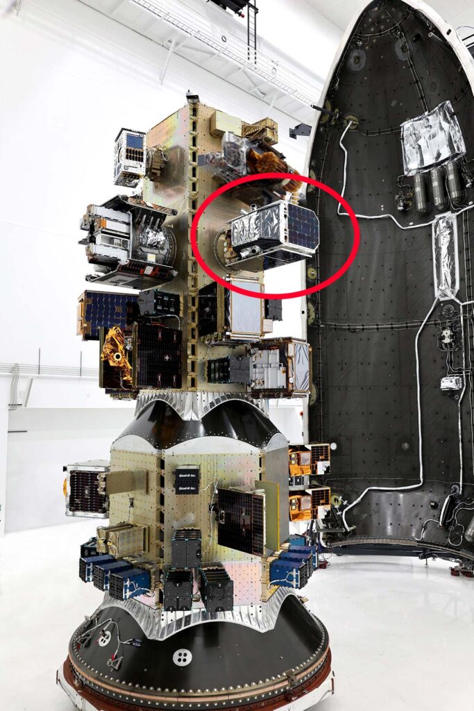
Second stage of the Falcon 9 rocket with its payload on the SpaceX Transporter-11 mission. Tanager-1 is circled in red.
Source: SpaceX, posted on Carbon Mapper LinkedIn
Even with all this painstaking planning, we still weren’t in the clear. But after over an hour of waiting, at “T+1:19:06” in rocket-speak, the Carbon Mapper Coalition’s satellite officially deployed from the rocket traveling 17,000 miles per hour some 324 miles above Earth.

Video feed of Tanager-1 satellite deployment from SpaceX rocket.
Source: SpaceX.com footage.
With the satellite safely in orbit, we could finally exhale on the ground. Yet, Carbon Mapper’s CEO, Riley Duren, was much calmer throughout the launch viewing. While at NASA, he told us he learned that “perseverance and cautious optimism are essential for longevity in the space world.”
Riley’s vision, leadership, and team spirit led to a unique institutional arrangement. Carbon Mapper (the nonprofit), spearheads the Carbon Mapper coalition, a cutting-edge collaboration of public, private, nonprofit, philanthropic, and academic institutions. The unwavering support by scientific, governmental, industry, and public interests is a superpower that fuels its mission to “accelerate local climate action, globally.” Carbon Mapper’s best-in-class data portal already includes tens of thousands of methane and CO2 point-source plumes observed from its airborne surveys and NASA’s EMIT instrument onboard the International Space Station. Tanager-1 observations will significantly scale up this public data.
Funding to date has been entirely philanthropic, with High Tide Foundation, Bloomberg Philanthropies, and other funders backing this critical climate mission. To continue to build a system-of-systems with many more eyes in the sky, however, private and government funding will be necessary.
Here are our reflections on this remarkable event we firsthand.
Debbie Gordon, RMI
Too rarely does life come full circle. But, today, it did for me.
My career began at Chevron, permitting a major oil and gas complex – platforms at Pt. Conception offshore Vandenberg Air Force Base, heated pipelines through private ranches for miles along the coast, and gas plant north of Santa Barbara at Gaviota.

Santa Barbara coastline across Highway 101 from the Gaviota gas plant (left) and a portion of the Gaviota gas plant and flare stack, which are now idled (center and right).
Source: Author’s photographs, August 15, 2024.
This summer, forty years later, I am driving up the Pacific coast headed to the launch of Carbon Mapper’s methane-sensing satellite. Thinking back, I recalled how federal and state environmental agencies systematically excluded methane emissions from the oil and gas facility permits. But why? At the time, it was thought that methane did not contribute to the smog that sickened Southern Californians. The decision was misguided. Today we know better: methane does react to form ground-level ozone, or smog. While these platforms have since been decommissioned and the pipelines and gas plant idled, there’s no telling how much methane they emitted over their lifetimes. If only there had been a super-emitting methane satellite in orbit to monitor, measure, and curtail emissions.
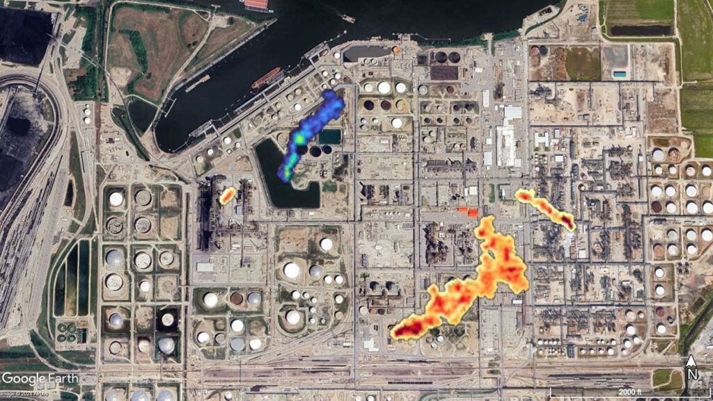
Plumes of methane (blue) and CO2 (orange) observed from an oil and gas facility by Carbon Mapper airborne surveys.
Source: Carbon Mapper data portal.
I believe that we can manage what we measure. This gives us hope that we will be able to spot and stop methane, a climate super pollutant that places over 80 blankets on the planet for every single blanket of carbon dioxide. The satellite also detects high emissions point sources of CO2. Mitigating both major climate pollutants simultaneously is the winning ticket.
Where do we go from here? RMI is turning Carbon Mapper, MethaneSAT, and other satellite data into action. We are incorporating these measurements into the OCI+ model, and WasteMap to analyze and develop climate mitigation strategies for oil and gas and landfills, respectively. We are working with governments to policy makers and corporates market makers to certify, buy, and sell low-methane gas (with less than 0.2 percent emission intensity). And, with global gas trade on the rise, we are doubling down on implementation of global methane pledges and charters. The years ahead promise to be the most impactful in a generation, informed by satellite measurements. Making invisible climate pollutant emissions, visible, is the game changer.
Marcia DeLonge, High Tide Foundation
With my young children in tow, we traveled eagerly to celebrate both a great feat of engineering and the beginning of a new era of methane transparency and accountability. As a scientist, I have been working on climate change for over two decades. At times the scope of the problem has felt deeply overwhelming, but it is this same scope that keeps me going: every dimension is an opportunity to make a difference.
Methane is particularly exciting, because as a short-lived climate pollutant it offers the fastest down payment we can make to address climate change. Furthermore, new data, paired with partners and action, will provide tremendous opportunities to slash methane across multiple sectors.
After the launch, my little ones were awestruck. “Up up, so high, mom!,” they shouted as they jumped gleefully into the air. I smiled, because their pure joy absolutely met the moment, and because the moment was setting them on course for a brighter future.
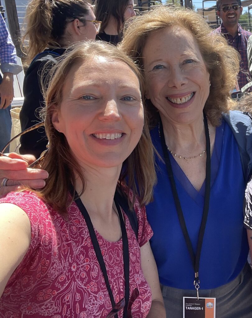
The authors, Debbie, RMI (right) and Marcia, High Tide Foundation (left) celebrating Carbon Mapper’s successful launch.
Source: Selfie, August 16, 2024.
We’re waiting again in anticipation of “first light” in the months ahead when Tanager-1 successfully transmits its initial observations. Then the bounty of super-emitting methane and CO2 emissions measurements will follow. With this growing body of climate intelligence, the sky’s the limit to hasten action.